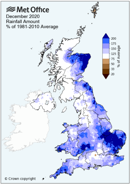
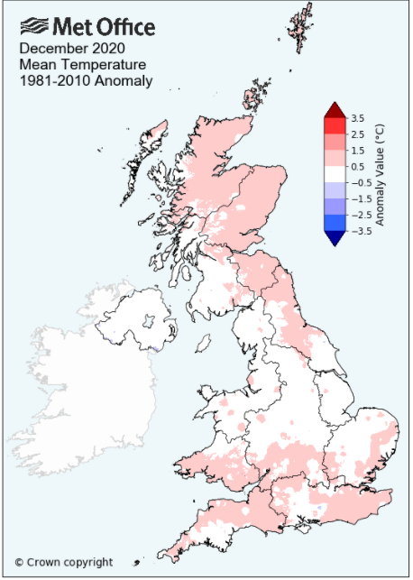
Slightly cooler and wetter than average - cool start and end, mild and wet middle
December was often mixed and unsettled and managed to fit in a little bit of everything: cool (recording the year's coldest temperature), mildness, wintry conditions, a wet spell, many calm days along with one named storm - but little in the way of sunshine, being very dull!
The month began on the cool side with some wintry conditions - through to the 9th there were a number of frosts and even on the nights that avoided a frost, it was only just. It then became very unsettled during the middle part of the month, milder, with rain every day and some fairly high daily totals. In the lead up to Christmas it became cooler with frosts through to the end of the month with the year ending with a 'Day of lying snow.
However, during this period Boxing Day and overnight into the 27th saw stormy weather as 'Storm Bella' swept south over the UK. Cumbria avoided the worst of the conditions, but it was comfortably the month's wettest day.
My short(ish) period of rainfall records (14yrs) does cover the wettest decade for December in local records, back to at least 1856 and therefore the mean rainfall for this site is possibly slightly inflated - but this December still managed to exceed it!
Both the number of air and ground frosts were above average and whilst it was just slightly colder than average, the cold start and end to the month was counter-balanced by the long mild stretch mid-month.
MSLP of 1000.7 Mb was -11.4 MB below the local average for the month and overall a mean minimum of 1.02°c and a mean maximum of 5.95°c saw the temperature 0.52°c below the eleven year average for this site.
It was the coldest since 2017 and of the twelve now recorded, 7 have been warmer and 4 have been colder - the highest maximum temperature recorded being 12.3°c (18th), the lowest minimum -5.2°c (25th).
Rainfall of 172.1 mm (Maulds Meaburn North 164.1 mm -- Castlehowe Scar 268.0 mm) was 105.1% of average for 2007-19 and made it the wettest December since 2015. Of the fourteen now recorded, 4 have been wetter and 9 have been drier.
During the month the following was recorded: snow fell on 7 days (3rd-4th, 24-25th, 27th, 29th + 31st), one day of 'Lying Snow' (31st), Hail on one day (20th), fog on two days (7th + 31st). The wind speed averaged 5.84 mph, with a maximum gust of 57 mph (26th).
At the Met' Office site at Newton Rigg a mean temperature of 3.96°c is 0.6°c warmer than average and is the coldest since 2017. In a series back to 1952, 37 have been colder and 32 have been warmer.
Rainfall totalled 147.4 mm (140.4% of average), making it the wettest since 2015. Since 1900 when the record began, 32 have been wetter and 98 have been drier (there is no data in two of the years).
At Appleby in Westmorland a total of 133.3 mm represented 137.7% of its average (1856-2019) and made it the wettest since 2015 - in a record that commenced in 1856, 34 have been wetter and 130 drier.
At Seathwaite Farm it was the driest since 2018 and in a record that commenced in 1845, 56 have been wetter and 119 have been drier.
Rainfall totals across Cumbria were generally above average, but not everywhere.
Figures from the Environment Agency�s rainfall sites were, (figure in brackets being the monthly average for 1961-90) �Data kindly provided by the Hydrometry and Telemetry team of the Environment Agency (Penrith)�:
Kirkby Thore 109.0 mm (71.7 mm)
Haresceugh Castle (Kirkoswald) 151.17 mm (85.1 mm)
Brothers Water 365.42 mm (304 mm) and
Orton (Shallowford) 220.4 mm (195.5 mm [average for 1967-2019])
481.2 mm at Seathwaite Farm (Borrowdale - 382 mm [average for 1981-2010]).
General Synoptic Report for the Month
After a weak ridge of high pressure (HP) brought a chilly night on the 1st (-2.7°c), low pressure (LP) then moved in to sit over or near to the UK. At times the LP broadened out which gave a very slack pressure gradient and thus calm conditions. However, the 3rd - 5th saw a northerly flow and this resulted in some wintry conditions, namely some snow in the early hours of both the 3rd and 4th. The 3rd at just 2.5°c felt rather cold and was, up to this point, the lowest daytime maximum of 2020.
The snow that fell on the 4th was the heavier fall of the two, giving a good cover at Penrith, not much at Morland, but here at Maulds Meaburn a very wet and rapidly melting cover that did not completely cover the ground. Whilst snow fell awhile during the morning this quickly turned to rain and the early promise of a snowy winter had come to an end.
The LP remained in charge though and after some brighter moments 5-6th, it was all a little gloomy and cold, although with little rain. The 7th was especially gloomy and grey with fog from overnight lasting most of the morning, but remaining murky into the evening. The last frost of the period fell on the 8th and from the 9th a new area of LP would arrive from off the Atlantic and it would now turn milder, and whilst not especially wet it still remained gloomy.
However, rainfall amounts were small up to the 12th, but the dullness of the weather was all pervading - then from the 13th it became even bleaker!
It also became noticeably milder, especially at night and now the rainfall totals started to tot up with some fairly heavy daily falls. A deep area of LP sat out in the Atlantic and would control the weather for the next few days before a new LP system took over on the 17th. The 13th and overnight into the 14th saw 23.7 mm of rain with the 14th then being especially dull and grey. The 15th saw a brief lull and even a little sunshine as the UK sat clear of fronts, but a subsidiary low pushed NE out of Biscay on the 16th, tracking over Eire and bringing another 15.5mm.
The new area of LP on the 17th likewise parked itself out to the west of Eire and pushed multiple fronts across the UK and from 1500 hrs on the 17th it didn't stop raining. This gave 20.6 mm (17th) and 16.2 mm (18th) and by now the ground was truly saturated - the 17th saw the total for 2020 top 1500 mm. Along with 2015 this is only the second year to have done so and 2020 got to that figure four days earlier than 2015.
The mildness also ramped up a few notches, the 17th being the first day of the month to top 10°c and then the 18th saw a maximum of 12.3°c (54.1°f), but accompanied by that rain. Behind the fronts associated to the LP, the 19th saw the temperature dip, becoming a showery day caused by trough lines circulating within the LP.
Light rain and/or showers for the next few days with the LP still nearby, but then in a slack pressure gradient on the 22nd we had the rare pleasure of some sun. Temperatures had taken a dip with day-time maximums just above 5°c and with a minor LP system moving away from Cornwall on the 23rd and HP in the Atlantic nudging north, a northerly flow was introduced. This gave a more raw feel to the 23rd and 24th, the latter managing a maximum temperature of 2.2°c having seen an overnight minimum of -2.4°c.
The 24th was also dry and brought to an end a 17 day 'Rain Spell' during which 121.7 mm of rain was recorded.
The 'cold spell' was short-lived, but it ensured a 'White Christmas', well at least a cold and frosty start, the temperature overnight falling to a year's low -5.2°c (22.6°f) on Christmas Day - but then the 'White Christmas' did arrive! A ten minute snow shower at 1150 hrs being more than enough to get that classification.
Christmas Day itself was cloudy but bright in the morning, but with cloud developing in the afternoon and then it was all change for Boxing Day. At first it was a case of waiting for 'Storm Bella' to arrive - the rain arrived early afternoon and with 26.6 mm it would become the month's wettest day, but the wind was probably a greater feature with gusts up to 57 mph, but overall it wasn't the worst of days.
It then turned cold for the rest of the month - the centre of the area of LP that was Bella slowly moved south into England and then into France (28-29th). Whilst the system had brisk northerly winds on its western flank, the bulk of the UK sat within the slack central area of the LP and now the temperatures fell away both by day and night. Once the fronts had cleared on the 27th, the temperature would only rise to 3.3°c and then after a frost of -2.4°c to start the 28th, the day itself could only manage 0.7°c (33.3°f), the year's lowest maximum temperature.
Day-time maximums remained low through to the end of the month and with some sharp frosts at night. The year would then end on a wintry note as during the early hours of the 31st a weak occlusion passed through and gave a few hours of light snow, enough to cover the ground come the morning. However, the day would start foggy and remain murky throughout with a little more snow at night.
Rainfall totalled 172.1 mm for the month, with rain recorded on 26 days of which 21 were 'Wet days' (1.0mm +).
The Mean Temperature for the month was 3.49°c -- The Mean Max' was 5.95°c -- The Mean Min' 1.02°c.
We had 11 Air Frosts in the month (year 36) -- Grass Frosts totalled 20 (year 121).
The 1 foot soil temp ranged from a low of 3.0°c on the 31st to a high of 8.0°c on the 19th -- with a monthly mean of 5.7°c
The 1 meter soil temp ranged from a low of 6.6°c on the 31st to a high of 9.1°c on the 1st -- with a monthly mean of 7.9°c
This makes the year of 2020 0.34°c warmer than the average for 2009-19 and with 128.4% of average rainfall for 2008-19
JANUARY 2010
FEBRUARY 2010
MARCH 2010
APRIL 2010
MAY 2010
JUNE 2010
JULY 2010
AUGUST 2010
SEPTEMBER 2010
OCTOBER 2010
NOVEMBER 2010
DECEMBER 2010
JANUARY 2011
FEBRUARY 2011
MARCH 2011
APRIL 2011
MAY 2011
JUNE 2011
JULY 2011
AUGUST 2011
SEPTEMBER 2011
OCTOBER 2011
NOVEMBER 2011
DECEMBER 2011
JANUARY 2012
FEBRUARY 2012
MARCH 2012
APRIL 2012
MAY 2012
JUNE 2012
JULY 2012
AUGUST 2012
SEPTEMBER 2012
OCTOBER 2012
NOVEMBER 2012
DECEMBER 2012
SUMMER 2012
REVIEW OF 2012
JANUARY 2013
FEBRUARY 2013
MARCH 2013
APRIL 2013
MAY 2013
JUNE 2013
JULY 2013
AUGUST 2013
SEPTEMBER 2013
OCTOBER 2013
NOVEMBER 2013
DECEMBER 2013
REVIEW OF 2013
JANUARY 2014
FEBRUARY 2014
MARCH 2014
APRIL 2014
MAY 2014
JUNE 2014
JULY 2014
AUGUST 2014
SEPTEMBER 2014
OCTOBER 2014
NOVEMBER 2014
DECEMBER 2014
WINTER 2014
REVIEW OF 2014
JANUARY 2015
FEBRUARY 2015
MARCH 2015
APRIL 2015
MAY 2015
JUNE 2015
JULY 2015
AUGUST 2015
SEPTEMBER 2015
OCTOBER 2015
NOVEMBER 2015
DECEMBER 2015
REVIEW OF 2015
JANUARY 2016
FEBRUARY 2016
MARCH 2016
APRIL 2016
MAY 2016
JUNE 2016
JULY 2016
AUGUST 2016
SEPTEMBER 2016
OCTOBER 2016
NOVEMBER 2016
DECEMBER 2016
REVIEW OF 2016
JANUARY 2017
FEBRUARY 2017
MARCH 2017
APRIL 2017
MAY 2017
JUNE 2017
JULY 2017
AUGUST 2017
SEPTEMBER 2017
OCTOBER 2017
NOVEMBER 2017
DECEMBER 2017
REVIEW OF 2017
JANUARY 2018
FEBRUARY 2018
MARCH 2018
APRIL 2018
MAY 2018
JUNE 2018
JULY 2018
AUGUST 2018
SEPTEMBER 2018
OCTOBER 2018
NOVEMBER 2018
DECEMBER 2018
REVIEW OF 2018
JANUARY 2019
FEBRUARY 2019
MARCH 2019
APRIL 2019
MAY 2019
JUNE 2019
JULY 2019
AUGUST 2019
SEPTEMBER 2019
OCTOBER 2019
NOVEMBER 2019
DECEMBER 2019
REVIEW OF 2019
JANUARY 2020
FEBRUARY 2020
MARCH 2020
APRIL 2020
MAY 2020
JUNE 2020
JULY 2020
AUGUST 2020
SEPTEMBER 2020
OCTOBER 2020
NOVEMBER 2020
OTHER ARTICLES
The Oldest Inhabitant
An Inch Of Scotch Mist
But it's meant to be Summer (Summer 2017)
© Darren Rogers 2010-20
Want to comment on this site? email